
Collins Landing, New York
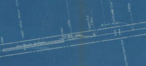
Valuation map of Collins Landing area
Mile 17.39
No station
Trackage: 294 foot stub siding
Of Notiation: this area was very swampy where there was a sink hole that had to be filled in as well as a pile trestle measuring circa 550 feet long due to how soft the land was for the right-of-way
Bay Pond, New York
Mile 18.70
Opened: 1895
Closed: 1937
The first station, a flag stop building, does exists. It was moved just north of its original location and is being used as a shed. Very well kept.
The second station remains on site. It was used as Bay Pond Inc.’s offices as well as a station, now has been converted into a residence.
Photographs: I do have a few photos of the stations for Bay Pond in my collection. These are available to be seen in person but I have agreed with the owners of the property that I would not post them here nor that they would be featured in my publication when it is printed.
Trackage: a passing siding north of the station existed at 554 feet in length
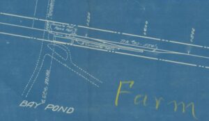
Valuation map of Bay Pond